
Bild:Tang outline map, 661.svg

Größe der PNG-Vorschau dieser SVG-Datei: 800 × 470 Pixels. Anner Oplösungen: 320 × 188 Pixels | 640 × 376 Pixels | 1.024 × 602 Pixels | 1.280 × 752 Pixels | 2.560 × 1.505 Pixels | 1.288 × 757 Pixels.
Originaldatei (SVG-Datei, Utgangsgrött: 1.288 × 757 Pixel, Dateigrött: 64 KB)
| Disse Datei warrt direkt vun Wikimedia Commons inbunnen. Angaven to'n Autor un de Lizenz staht op de Sied to de Datei bi Commons. |
Beschrieven
| Beschreibung |
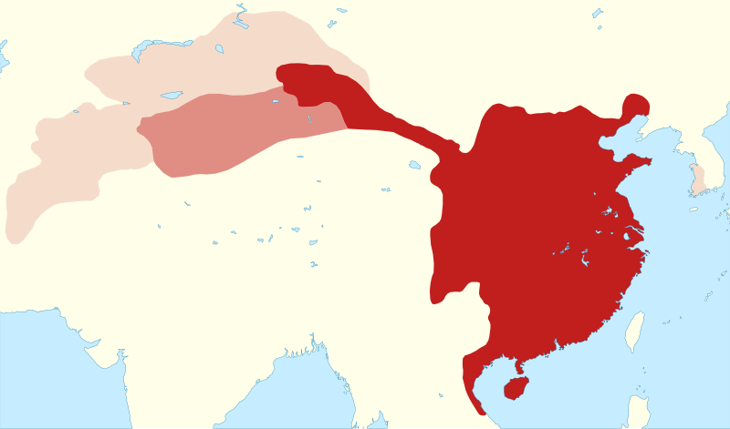
English: Outline map of the Tang empire in 661, when it reached its greatest extent. |
|||||||||
| Legende |
civil administration
military administration (Anxi protectorate): 649–670 and 675–755
briefly-controlled areas: Kunling, Mengchi, Sogdiana and Tokharistan protectorates (established 657–661, overthrown 665), Ungjin Commandery (660–671) |
|||||||||
| Datum/Tiet | ||||||||||
| Born |
Egen Wark
|
|||||||||
| Maker | ||||||||||
| Kartografische Angaben | ||||||||||
| Abgebildetes Datum | ||||||||||
| Koordinatenbezugssystem | equirectangular | |||||||||
| Orientierung |
 |
|||||||||
| Räumliche Begrenzung |
|
|||||||||
| Annere Versionen |
 |
|||||||||
| SVG‑Erstellung | De Borntext von Dit Vektorbild is mit Other tools opstellt worrn. |
|||||||||
Lizenz
Ik, Autor vun disse Datei, geev ehr hiermit ünner disse Lizenzen free:
Diese Datei ist lizenziert unter der Creative-Commons-Lizenz „Namensnennung – Weitergabe unter gleichen Bedingungen 4.0 international“.
- Du dröffst:
- wiedergeven – Kopien maken, an Annere wiedergeven un överdregen
- nee tohoopsetten – dat Wark verännern
- Ünner disse Bedingen:
- Naam nömen – Du musst den Naam von’n Autor oder von’n Afspraakgever in de von em fastleggte Wies nömen (aver nich so, dat dat utsüht, as wenn he di oder dien Gebruuk von dat Wark ünnerstütten deit).
- egaal wiedergeven – Wenn du dit Wark ännerst, afwannelst oder in en eegen Wark inboost, dörffst du dat nie’e Wark, dat dor bi rutkummt, man ünner desülve Afspraak oder een, de so temlich dat sülve is, rutgeven.

|
Ünner de Maatgaven vun de GNU free Lizenz för Dokumentatschoon, Version 1.2 oder en latere Version, rutgeven vun de Free Software Foundation;, dörffst du disse Datei koperen, wiedergeven un/oder ännern; dat gifft keene unverännerlichen Afsneed un keen Ümslagtext vörn oder achtern. Den fullen Text vun den Afspraak is in't Kapitel GNU-Afspraak för friee Dokumentaschion verfögbar. |
Du kannst di de Lizenz utsöken, de di opbest gefallt.
Datei-Historie
Klick op de Tiet, dat du de Datei ankieken kannst, so as se do utseeg.
| Datum/Tiet | Duumnagelbild | Grött | Bruker | Kommentoor | |
|---|---|---|---|---|---|
| aktuell | 09:48, 27. Mär 2024 | | 1.288 × 757 (64 KB) | Kanguole | fix XML markup errors (bad characters in id's) |
| 00:52, 25. Mär 2024 |  | 1.288 × 757 (64 KB) | Kanguole | minor update to northern boundary | |
| 22:46, 22. Jun. 2023 |  | 1.288 × 757 (63 KB) | Kanguole | add Ungjin Commandery (660–671) | |
| 17:18, 7. Mai 2023 |  | 1.195 × 757 (56 KB) | Kanguole | {{Map |Description={{en|1=Outline map of the Tang empire in 661, when it reached its greatest extent.}} |Legend= {{legend|#c11e1e|civil administration}} {{legend|#df8d83|military administration (Anxi protectorate): 649–670 and 675–755}} {{legend|#f7dcca|briefly-controlled protectorates (Kunling, Mengchi, Sogdiana, Tokharistan): established 657–661, overthrown 665}} |Date=2023-05-07 |Source={{own}} * Boundaries from ** Twitchett, Denis and Wechsler, Howard J. (1979). "Kao-tsung (reign 649-83)... |
Dateibruuk
Disse Sied bruukt dit Bild:
Allmeen Datei-Bruuk
Disse annern Wikis bruukt disse Datei:
- Bruuk op de.wikipedia.org
- Bruuk op en.wikipedia.org
- Bruuk op fa.wikipedia.org
- Bruuk op ko.wikipedia.org
- Bruuk op sl.wikipedia.org
- Bruuk op th.wikipedia.org
- Bruuk op tr.wikipedia.org
- Bruuk op uk.wikipedia.org
- Bruuk op uz.wikipedia.org