
Bild:Carleton Coon races after Pleistocene.PNG
Originaldatei (1.357 × 628 Pixel, Grött: 36 KB, MIME-Typ: image/png)
| Disse Datei warrt direkt vun Wikimedia Commons inbunnen. Angaven to'n Autor un de Lizenz staht op de Sied to de Datei bi Commons. |
Beschrieven
| Beschrievung |
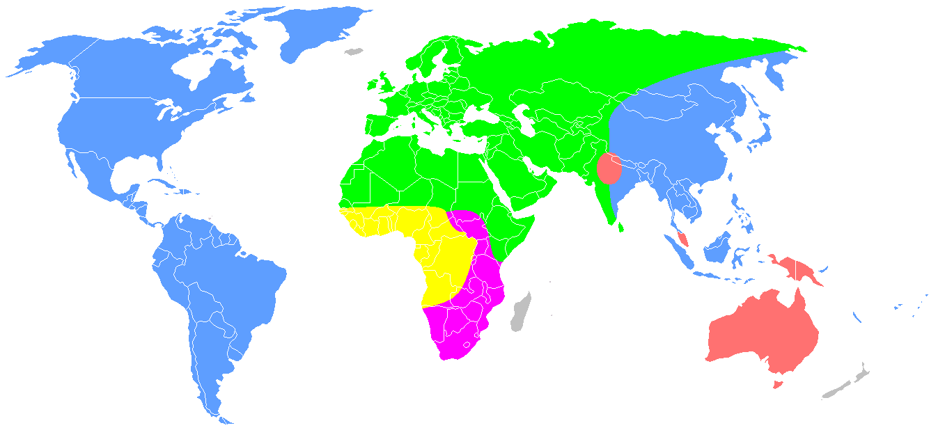
English: Redrawing of a map from Carleton S. Coon, The Origin of Races (1962), p. 659.
Distribution of Coon's "five geographical races of man" after the end of the Pleistocene. This is the second of the two maps numbered "Map 13", labelled "Early Post-Pleistocene". Original caption: "The second map shows what happened at the end of the Pleistocene, when the Mongoloids and Caucasoids expanded and burst out of their territories. The Mongoloids entered and inhabited America, and extended their domain southward into Southeast Asia and Indonesia, while the Australoids crossed Wallace's Line and occupied Australia and New Guinea. The Caucasoids thrust northward. More significantly, they drove the Capoids out of North Africa and occupied the White Highlands of Kenya and Tanganyika. The Congoids were reduced to a small part of their earlier domain, including the Congo forests and the lands to the north, where they later evolved rapidly and spread, as Negroes, over much of Africa." Some of these hypotheses are no longer tenable, it is now known that the Proto-Australoid peopling of Australia is much earlier, and that the Capoids developed in South, not North Africa.
|
| Datum/Tiet | 1. Oktober 2007 (Datum, as de Datei toeerst hooglaadt worrn is) |
| Born | Överdragen von en.wikipedia na Commons. free-use map of the world from Wikipedia Commons. "The living Races of Man"[1][2] |
| Autor | Dark Tea op de Wikipedia op Engelsch |
| Annere Versionen |
 |

|
Dit biogeographical map Bild schull man noch wedder as SVG-Datei (Vektor-Grafik) tekent warrn. Dat hett en Reeg Vördelen; bi Commons:Media for cleanup steit dor mehr to. Wenn dat al en SVG-Datei dorto gifft, denn laad ehr hooch. Na dat Hoochladen kannst du disse Vörlaag gegen {{vector version available|Nee Dateinaam.svg}} utwesseln.
|
Legend
| Australoids | ||
| Mongoloids | ||
| Caucasoids | ||
| Capoids | ||
| Congoids |
Lizenz

|
Ünner de Maatgaven vun de GNU free Lizenz för Dokumentatschoon, Version 1.2 oder en latere Version, rutgeven vun de Free Software Foundation;, dörffst du disse Datei koperen, wiedergeven un/oder ännern; dat gifft keene unverännerlichen Afsneed un keen Ümslagtext vörn oder achtern. Den fullen Text vun den Afspraak is in't Kapitel GNU-Afspraak för friee Dokumentaschion verfögbar. |
- Du dröffst:
- wiedergeven – Kopien maken, an Annere wiedergeven un överdregen
- nee tohoopsetten – dat Wark verännern
- Ünner disse Bedingen:
- Naam nömen – Du musst den Naam von’n Autor oder von’n Afspraakgever in de von em fastleggte Wies nömen (aver nich so, dat dat utsüht, as wenn he di oder dien Gebruuk von dat Wark ünnerstütten deit).
- egaal wiedergeven – Wenn du dit Wark ännerst, afwannelst oder in en eegen Wark inboost, dörffst du dat nie’e Wark, dat dor bi rutkummt, man ünner desülve Afspraak oder een, de so temlich dat sülve is, rutgeven.
Ursprüngliches Datei-Logbuch
- 2007-10-01 10:13 Dark Tea 1357×628×8 (48426 bytes) This is a recreation of Carleton Coon's racial map [http://www.snpa.nordish.net/index2.htm source]. It is made from a free-use image of the world found on Wikipedia. It is made to replace the previous I made which was innacurate.--~~~~
- ↑ https://www.jstor.org/stable/2740426?seq=1#page_scan_tab_contents
- ↑ https://archive.org/stream/B-001-001-289#page/n567/mode/2up
Datei-Historie
Klick op de Tiet, dat du de Datei ankieken kannst, so as se do utseeg.
| Datum/Tiet | Duumnagelbild | Grött | Bruker | Kommentoor | |
|---|---|---|---|---|---|
| aktuell | 12:20, 19. Okt. 2020 | | 1.357 × 628 (36 KB) | Bidgee | Reverted to version as of 09:48, 19 October 2020 (UTC) Enough! COM:OVERWRITE is there for a reason and is on the very page used to upload and revert. Please stop. |
| 12:10, 19. Okt. 2020 |  | 1.357 × 628 (35 KB) | Intonraiha | ? I have already included a new reference. Read it. | |
| 11:48, 19. Okt. 2020 |  | 1.357 × 628 (36 KB) | Rsk6400 | Reverted to version as of 19:22, 25 September 2020 (UTC) - See Discussion, section "South Asia". If you have a better source, name it on the discussion page. | |
| 11:01, 19. Okt. 2020 |  | 1.357 × 628 (35 KB) | Intonraiha | It is not sourced. The source does support this map. As others have discussed in the talk page. The references clearly mention the border as with in this version. It is not about Coons first version. | |
| 21:55, 18. Okt. 2020 |  | 1.357 × 628 (36 KB) | Rsk6400 | Reverted to version as of 19:22, 25 September 2020 (UTC) - This version corresponds to Coon's original version | |
| 21:58, 9. Okt. 2020 |  | 1.357 × 628 (35 KB) | BoxofPandoraisopened | Restoring cited version. If we use such a map, we should use the version which Coon ultimately proposed and not a prototype version. | |
| 21:22, 25. Sep. 2020 |  | 1.357 × 628 (36 KB) | Fæ | Reverted to version as of 09:48, 25 September 2020 (UTC) Restore, per File:The Origin of Races, map 13 (IA B-001-001-289).jpg. Please avoid adding user interpretations when the published 1962 map can be directly referenced. | |
| 21:04, 25. Sep. 2020 |  | 1.357 × 628 (34 KB) | Fylindfotberserk | I'm restoring the south Asian part as per "Living Races Of Man" and "The Origin of Races", plains of Assam (Brahmaputra) and Bengal are settled by Caucasoids. page 485 of "The Origin of Races" writes "Caucasoid and Mongoloid had a common border at the "Edges of the Assam and Bengal plains." | |
| 11:48, 25. Sep. 2020 |  | 1.357 × 628 (36 KB) | Fæ | Reverted to version as of 14:58, 10 March 2018 (UTC) removing the changes of multiple sockpuppet accounts | |
| 03:06, 15. Aug. 2019 |  | 1.357 × 628 (35 KB) | LenguaMapa | Reverted to version as of 19:07, 1 July 2019 (UTC) revert back (this is after pleistocene...) |
.jpg&action=edit&redlink=1)
Dateibruuk
Kene Siet bruukt dat Bild.
Allmeen Datei-Bruuk
Disse annern Wikis bruukt disse Datei:
- Bruuk op bg.wikipedia.org
- Bruuk op en.wikipedia.org
- Bruuk op es.wikipedia.org
- Bruuk op fr.wikipedia.org
- Bruuk op hr.wikipedia.org
- Bruuk op it.wikipedia.org
- Bruuk op ml.wikipedia.org
- Bruuk op no.wikipedia.org
- Bruuk op tl.wikipedia.org
- Bruuk op uk.wikipedia.org