
Bild:Bulgaria Simeon I (893-927).svg

Größe der PNG-Vorschau dieser SVG-Datei: 627 × 599 Pixels. Anner Oplösungen: 251 × 240 Pixels | 502 × 480 Pixels | 803 × 768 Pixels | 1.071 × 1.024 Pixels | 2.142 × 2.048 Pixels | 752 × 719 Pixels.
Originaldatei (SVG-Datei, Utgangsgrött: 752 × 719 Pixel, Dateigrött: 232 KB)
| Disse Datei warrt direkt vun Wikimedia Commons inbunnen. Angaven to'n Autor un de Lizenz staht op de Sied to de Datei bi Commons. |
| Beschrievung | |
| Datum/Tiet | created and uploaded 4 March 2007 |
| Born | Egen Wark |
| Autor | Todor Bozhinov |
| Lizenz/Verlööv (Disse Datei annerwegens bruken) |
Diese Datei ist unter der Creative-Commons-Lizenz „Namensnennung – Weitergabe unter gleichen Bedingungen 2.5 generisch“ (US-amerikanisch) lizenziert.
|
| Annere Versionen |
[]
|
cs.png)
.png)
.svg)
_es.svg)
-hu.svg)
_pt.svg)
-zh.svg)
-ar.svg)
.svg)
Notes
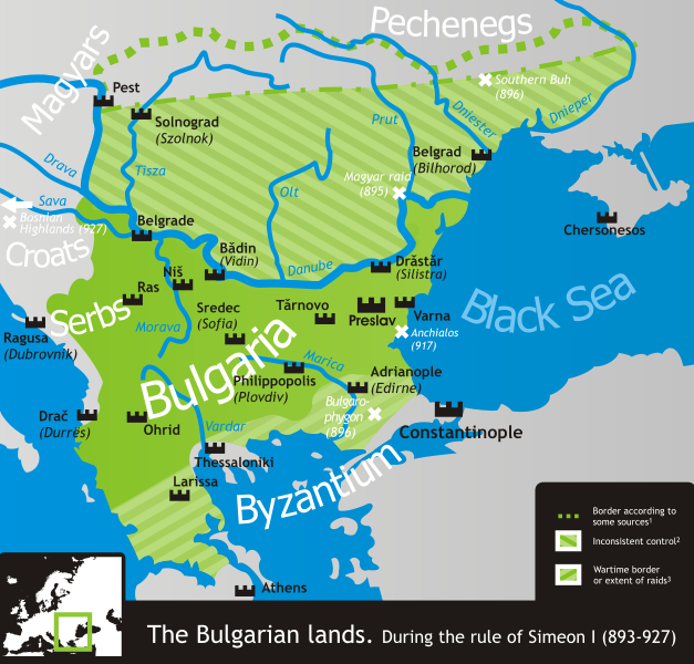
- 1 According to, among others, Crampton, Delev, Dobrev and Lalkov.
- 2 Bulgaria ruled all land east of the Danube and west of the Dnieper according to Constantine VII's De Administrando Imperio (c. 950), but actual Bulgarian control was often partial, weak and/or inconsistent in many of the scarcely-populated areas north of the Danube.
- 3 That is, unconfirmed by a peace treaty and only controlled during military campaigns in the Byzantine lands. These, however, comprised much if not most of Simeon's rule.
- The northern border is conjectural, as its exact location is practically unattested.
References
- Crampton, R.J. (2005) A Concise History of Bulgaria, Cambridge University Press, S. p. 13 ISBN 0521850851
- Delev, Petǎr; Valeri Kacunov, Plamen Mitev, Evgenija Kalinova, Iskra Baeva, Bojan Dobrev (2006) „9 Bǎlgarskata dǎržava pri Car Simeon“ in (bulgarian) Istorija i civilizacija za 11. klas, Trud, Sirma
- Dobrev, Hristo (1979) (bulgarian) Bǎlgarski voenen atlas, Sofia: Voenno izdatelstvo, S. pp. 152−153 OCLC 46136451
- Koledarov, Petǎr (1989) (bulgarian) Političeska geografija na srednovekovnata bǎlgarska dǎržava 2 (1186–1396), Bulgarian Academy of Sciences
- Lalkov, Milčo (1997) Rulers of Bulgaria, Kibea, S. p. 24, p. 66 ISBN 954-474-098-8
| Annotations | This image is annotated: View the annotations at Commons |
.svg)
Datei-Historie
Klick op de Tiet, dat du de Datei ankieken kannst, so as se do utseeg.
.svg&dir=prev)
.svg&offset=20070304205903)
.svg&offset=&limit=20)
.svg&offset=&limit=50)
.svg&offset=&limit=100)
.svg&offset=&limit=250)
.svg&offset=&limit=500)
| Datum/Tiet | Duumnagelbild | Grött | Bruker | Kommentoor | |
|---|---|---|---|---|---|
| aktuell | 16:50, 18. Nov. 2019 | | 752 × 719 (232 KB) | Claude Zygiel | Side |
| 16:49, 18. Nov. 2019 |  | 744 × 1.052 (520 KB) | Claude Zygiel | Details | |
| 22:38, 18. Feb. 2011 |  | 752 × 719 (232 KB) | Ilmari Karonen | add missing xmlns attribute(s) | |
| 22:49, 7. Mär 2007 | Keen lütt Bild | (232 KB) | Martyr | ||
| 11:13, 6. Mär 2007 | Keen lütt Bild | (232 KB) | Martyr | ||
| 23:10, 5. Mär 2007 | Keen lütt Bild | (230 KB) | Martyr | ||
| 22:03, 5. Mär 2007 | Keen lütt Bild | (230 KB) | Martyr | larger names of battles, etc. | |
| 21:29, 5. Mär 2007 | Keen lütt Bild | (232 KB) | Martyr | names of some important battles, etc. | |
| 12:22, 5. Mär 2007 | Keen lütt Bild | (211 KB) | Martyr | river names, Thessaloniki name, rm line (northern border is conjectural), etc. | |
| 22:59, 4. Mär 2007 | Keen lütt Bild | (194 KB) | Martyr | new |
Dateibruuk
Disse Sied bruukt dit Bild:
Allmeen Datei-Bruuk
Disse annern Wikis bruukt disse Datei:
- Bruuk op ar.wikipedia.org
- Bruuk op bn.wikipedia.org
- Bruuk op ckb.wikipedia.org
- Bruuk op da.wikipedia.org
- Bruuk op de.wikipedia.org
- Bruuk op el.wikipedia.org
- Bruuk op en.wikipedia.org
- Bruuk op eo.wikipedia.org
- Bruuk op es.wikipedia.org
- Bruuk op eu.wikipedia.org
- Bruuk op fa.wikipedia.org
- Bruuk op fr.wikipedia.org
- Bruuk op he.wikipedia.org
- Bruuk op hr.wikipedia.org
- Bruuk op hy.wikipedia.org
- Bruuk op it.wikipedia.org
- Bruuk op ja.wikipedia.org
- Bruuk op ka.wikipedia.org
- Bruuk op kk.wikipedia.org
- Bruuk op lt.wikipedia.org
- Bruuk op lv.wikipedia.org
- Bruuk op mk.wikipedia.org
- Bruuk op nl.wikipedia.org
- Bruuk op no.wikipedia.org
- Bruuk op oc.wikipedia.org
- Bruuk op pl.wikipedia.org
- Bruuk op pt.wikipedia.org
- Bruuk op ro.wikipedia.org
Kiek na mehr almeen Bruuk von disse Datei.
.svg)
.svg)