
Bild:Afsluitdijk Netherlands Satellite Photo by Sentinel-2 30 June 2018.jpg

Originaldatei (4.305 × 3.847 Pixel, Grött: 12,89 MB, MIME-Typ: image/jpeg)
| Disse Datei warrt direkt vun Wikimedia Commons inbunnen. Angaven to'n Autor un de Lizenz staht op de Sied to de Datei bi Commons. |
Beschrieven
| Beschrievung |
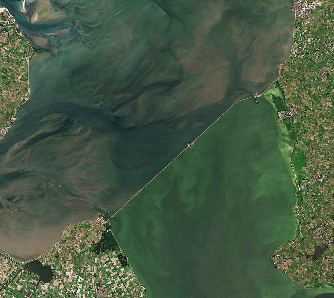
English: A satellite photo of the Afsluitdijk, The Netherlands, 30 June 2018. The Afsluitdijk changed the Zuiderzee into the IJsselmeer. To the north of the Afsluitdijk is the Wadden Sea, to the south is the IJsselmeer. Sensor: MSI on Sentinel-2A. Resolution: 10m. RGB Composites: True color, Band 4-3-2.
Nederlands: Een satellietfoto van de Afsluitdijk, Nederland, 30 juni 2018. De afsluitdijk veranderde de Zuiderzee in het IJsselmeer. Ten noorden van de Afsluitdijk is de Waddenzee, ten zuiden is het IJsselmeer. Sensor: MSI op Sentinel-2A. Resolutie: 10m. RGB-composieten: Ware Kleuren, Band 4-3-2. |
| Datum/Tiet | |
| Born | |
| Autor | Copernicus Sentinel-2, ESA |
.jpg)
Lizenz
- Du dröffst:
- wiedergeven – Kopien maken, an Annere wiedergeven un överdregen
- nee tohoopsetten – dat Wark verännern
- Ünner disse Bedingen:
- Naam nömen – Du musst den Naam von’n Autor oder von’n Afspraakgever in de von em fastleggte Wies nömen (aver nich so, dat dat utsüht, as wenn he di oder dien Gebruuk von dat Wark ünnerstütten deit).
- egaal wiedergeven – Wenn du dit Wark ännerst, afwannelst oder in en eegen Wark inboost, dörffst du dat nie’e Wark, dat dor bi rutkummt, man ünner desülve Afspraak oder een, de so temlich dat sülve is, rutgeven.

|
This image contains data from a satellite in the Copernicus Programme, such as Sentinel-1, Sentinel-2 or Sentinel-3. Attribution is required when using this image.
Naam nömen: Contains modified Copernicus Sentinel data 2018
The use of Copernicus Sentinel Data is regulated under EU law (Commission Delegated Regulation (EU) No 1159/2013 and Regulation (EU) No 377/2014). Relevant excerpts:
Free access shall be given to GMES dedicated data [...] made available through GMES dissemination platforms [...].
Access to GMES dedicated data [...] shall be given for the purpose of the following use in so far as it is lawful:
GMES dedicated data [...] may be used worldwide without limitations in time.
GMES dedicated data and GMES service information are provided to users without any express or implied warranty, including as regards quality and suitability for any purpose. |
Datei-Historie
Klick op de Tiet, dat du de Datei ankieken kannst, so as se do utseeg.
| Datum/Tiet | Duumnagelbild | Grött | Bruker | Kommentoor | |
|---|---|---|---|---|---|
| aktuell | 09:27, 4. Jul. 2023 | | 4.305 × 3.847 (12,89 MB) | Artanisen | Uploaded a work by Copernicus Sentinel-2, ESA from Extracted from: North Holland with parts of Friesland and Flevoland by Sentinel-2 (Original 10m Res).jpg with UploadWizard |
Dateibruuk
Disse Sied bruukt dit Bild:
Allmeen Datei-Bruuk
Disse annern Wikis bruukt disse Datei:
- Bruuk op af.wikipedia.org
- Bruuk op arz.wikipedia.org
- Bruuk op ast.wikipedia.org
- Bruuk op ca.wikipedia.org
- Bruuk op cs.wikipedia.org
- Bruuk op de.wikipedia.org
- Bruuk op en.wikipedia.org
- Bruuk op eo.wikipedia.org
- Bruuk op es.wikipedia.org
- Bruuk op fr.wikipedia.org
- Bruuk op fy.wikipedia.org
- Bruuk op hu.wikipedia.org
- Bruuk op ja.wikipedia.org
- Bruuk op ko.wikipedia.org
- Bruuk op nds-nl.wikipedia.org
- Bruuk op nl.wikipedia.org
- Bruuk op pl.wikipedia.org
- Bruuk op pt.wikipedia.org
- Bruuk op www.wikidata.org