Diese Landkarte verwendet das SVG-switch-Element zur Mehrsprachigkeit.
Versions
Non-modifiable text
Clickable
Lizenz
Ünner de Maatgaven vun de GNU free Lizenz för Dokumentatschoon, Version 1.2 oder en latere Version, rutgeven vun de Free Software Foundation;, dörffst du disse Datei koperen, wiedergeven un/oder ännern; dat gifft keene unverännerlichen Afsneed un keen Ümslagtext vörn oder achtern. Den fullen Text vun den Afspraak is in't Kapitel GNU-Afspraak för friee Dokumentaschion verfögbar.http://www.gnu.org/copyleft/fdl.htmlGFDLGNU Free Documentation Licensetruetrue
wiedergeven – Kopien maken, an Annere wiedergeven un överdregen
nee tohoopsetten – dat Wark verännern
Ünner disse Bedingen:
Naam nömen – Du musst den Naam von’n Autor oder von’n Afspraakgever in de von em fastleggte Wies nömen (aver nich so, dat dat utsüht, as wenn he di oder dien Gebruuk von dat Wark ünnerstütten deit).
egaal wiedergeven – Wenn du dit Wark ännerst, afwannelst oder in en eegen Wark inboost, dörffst du dat nie’e Wark, dat dor bi rutkummt, man ünner desülve Afspraak oder een, de so temlich dat sülve is, rutgeven.
Diese Lizenzmarkierung wurde auf Grund der GFDL-Lizenzaktualisierung hinzugefügt.http://creativecommons.org/licenses/by-sa/3.0/CC BY-SA 3.0Creative Commons Attribution-Share Alike 3.0truetrue
wiedergeven – Kopien maken, an Annere wiedergeven un överdregen
nee tohoopsetten – dat Wark verännern
Ünner disse Bedingen:
Naam nömen – Du musst den Naam von’n Autor oder von’n Afspraakgever in de von em fastleggte Wies nömen (aver nich so, dat dat utsüht, as wenn he di oder dien Gebruuk von dat Wark ünnerstütten deit).
egaal wiedergeven – Wenn du dit Wark ännerst, afwannelst oder in en eegen Wark inboost, dörffst du dat nie’e Wark, dat dor bi rutkummt, man ünner desülve Afspraak oder een, de so temlich dat sülve is, rutgeven.
Disse Datei bargt noch mehr Informatschonen, de mehrsttiets vun de Digitalkamera oder den Scanner kaamt. Dör Afännern vun de Originaldatei köönt welk Details nich mehr ganz to dat Bild passen.


 anarâškielâ
 bosanski
 Diné bizaad
 eesti
eesti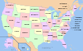 English and all languages
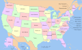 English
 español
 Esperanto
 euskara
 français
 galego
 Hawaiʻi
 hrvatski
 italiano
 magyar
 occitan PNG
 polski
 português
 română
 Scots
Scots slovenčina
 suomi
suomi svenska
 ślůnski
 Ἀρχαία ἑλληνικὴ
 Ελληνικά
 български
 македонски
 нохчийн
 русский
 русский 2
 српски (ћирилица)
 українська
 ქართული PNG
 қазақша
 मराठी
मराठी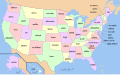 हिन्दी
 অসমীয়া
 বাংলা
বাংলা বিষ্ণুপ্রিয়া মণিপুরী
 ਪੰਜਾਬੀ
 മലയാളം
 ไทย
ไทย ᏣᎳᎩ
ᏣᎳᎩ 中文(简体)
 中文(繁體)
 עברית
עברית اردو
اردو العربية
 فارسی
فارسی فارسی JPG


.svg)


