
Bild:PrairiePotholeRegionMap.gif
Gifft dat Bild nich grötter.
PrairiePotholeRegionMap.gif (295 × 302 Pixel, Grött: 5 KB, MIME-Typ: image/gif)
| Disse Datei warrt direkt vun Wikimedia Commons inbunnen. Angaven to'n Autor un de Lizenz staht op de Sied to de Datei bi Commons. |
Beschrieven

|
Dit map Bild schull man noch wedder as SVG-Datei (Vektor-Grafik) tekent warrn. Dat hett en Reeg Vördelen; bi Commons:Media for cleanup steit dor mehr to. Wenn dat al en SVG-Datei dorto gifft, denn laad ehr hooch. Na dat Hoochladen kannst du disse Vörlaag gegen {{vector version available|Nee Dateinaam.svg}} utwesseln.
|
| Beschrievung |
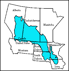
English: Map of the Prairie Pothole Region of North America. From the US Geological Survey, http://www.npwrc.usgs.gov/resource/wetlands/pothole/prairie.htm |
| Born | |
| Autor |
Lizenz
Dieses Bild ist gemeinfrei (public domain), weil es Materialien beeinhaltet, die ursprünglich vom United States Geological Survey, einer Behörde des Innenministeriums der Vereinigten Staaten, stammen. Weitere Informationen finden Sie in den Urheberrechtsbestimmungen des USGS
|
Ursprüngliches Datei-Logbuch
Die ursprüngliche Dateibeschreibungsseite war hier. Alle folgenden Benutzernamen beziehen sich auf en.wikipedia.
- 2007-10-15 17:21 Orlady 295×302×8 (4921 bytes) Map of the Prairie Pothole Region of North America. From the US Geological Survey, http://www.npwrc.usgs.gov/resource/wetlands/pothole/prairie.htm
Datei-Historie
Klick op de Tiet, dat du de Datei ankieken kannst, so as se do utseeg.
| Datum/Tiet | Duumnagelbild | Grött | Bruker | Kommentoor | |
|---|---|---|---|---|---|
| aktuell | 03:53, 6. Apr. 2008 | | 295 × 302 (5 KB) | File Upload Bot (Magnus Manske) | {{BotMoveToCommons|en.wikipedia}} {{Information |Description={{en|Map of the Prairie Pothole Region of North America. From the US Geological Survey, http://www.npwrc.usgs.gov/resource/wetlands/pothole/prairie.htm}} |Source=Transferred from [http://en.wik |
Dateibruuk
Disse Sied bruukt dit Bild:
Allmeen Datei-Bruuk
Disse annern Wikis bruukt disse Datei:
- Bruuk op af.wikipedia.org
- Bruuk op de.wikipedia.org
- Bruuk op en.wikipedia.org
- Bruuk op www.wikidata.org