
Bild:Map of Indiana highlighting Brown County.svg

Größe der PNG-Vorschau dieser SVG-Datei: 391 × 599 Pixels. Anner Oplösungen: 156 × 240 Pixels | 313 × 480 Pixels | 501 × 768 Pixels | 668 × 1.024 Pixels | 1.337 × 2.048 Pixels | 2.887 × 4.423 Pixels.
Originaldatei (SVG-Datei, Utgangsgrött: 2.887 × 4.423 Pixel, Dateigrött: 56 KB)
| Disse Datei warrt direkt vun Wikimedia Commons inbunnen. Angaven to'n Autor un de Lizenz staht op de Sied to de Datei bi Commons. |
Beschrieven
| Beschrievung |
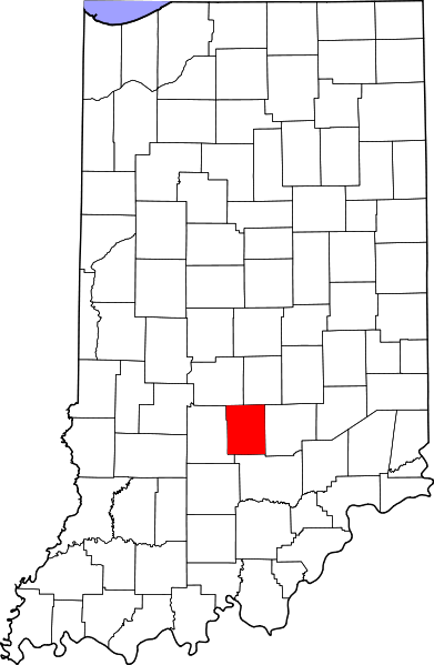
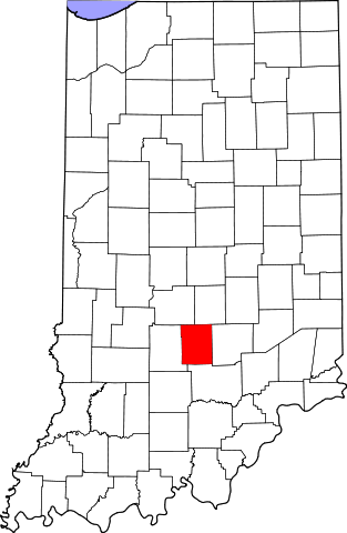
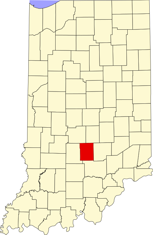
English: This is a locator map showing Brown County in Indiana. For more information, see Commons:United States county locator maps. |
| Datum/Tiet | |
| Born |
Egen Wark: English: The maps use data from nationalatlas.gov, specifically countyp020.tar.gz on the Raw Data Download page. The maps also use state outline data from statesp020.tar.gz. The Florida maps use hydrogm020.tar.gz to display Lake Okeechobee. |
| Autor | David Benbennick |
Lizenz
| Ich, der Urheberrechtsinhaber dieses Werkes, veröffentliche es als gemeinfrei. Dies gilt weltweit. Wenn dat na lokale Rechtslaag nich mööglich is, gellt: Ich gewähre jedem das bedingungslose Recht, dieses Werk für jedweden Zweck zu nutzen, es sei denn, Bedingungen sind gesetzlich erforderlich. |
Datei-Historie
Klick op de Tiet, dat du de Datei ankieken kannst, so as se do utseeg.
| Datum/Tiet | Duumnagelbild | Grött | Bruker | Kommentoor | |
|---|---|---|---|---|---|
| aktuell | 14:09, 12. Feb. 2006 | | 2.887 × 4.423 (56 KB) | David Benbennick | {{subst:User:Dbenbenn/clm|county=Brown County|state=Indiana}} |
Dateibruuk
Disse Sied bruukt dit Bild:
Allmeen Datei-Bruuk
Disse annern Wikis bruukt disse Datei:
- Bruuk op ar.wikipedia.org
- Bruuk op azb.wikipedia.org
- Bruuk op bg.wikipedia.org
- Bruuk op bpy.wikipedia.org
- Bruuk op cdo.wikipedia.org
- Bruuk op ceb.wikipedia.org
- Bruuk op ce.wikipedia.org
- Bruuk op cy.wikipedia.org
- Bruuk op de.wikipedia.org
- Bruuk op en.wikipedia.org
- List of counties in Indiana
- Brown County, Indiana
- Nashville, Indiana
- Gnaw Bone, Indiana
- Weed Patch Hill
- Knobstone Escarpment
- Belmont, Indiana
- Beanblossom, Indiana
- Hamblen Township, Brown County, Indiana
- Jackson Township, Brown County, Indiana
- Van Buren Township, Brown County, Indiana
- Washington Township, Brown County, Indiana
- Template:Brown County, Indiana
- Template:BrownCountyIN-geo-stub
- Christiansburg, Indiana
- Cornelius, Indiana
- Elkinsville, Indiana
- Fruitdale, Indiana
- Gatesville, Indiana
- Taggart, Indiana
- Lanam, Indiana
- Mount Liberty, Indiana
- Needmore, Brown County, Indiana
- Pikes Peak, Indiana
- Spearsville, Indiana
- Stone Head, Indiana
- Story, Indiana
Kiek na mehr almeen Bruuk von disse Datei.