
Bild:C77141s1 Ant.Map Boyd Glacier.jpg

Grött vun disse Vörschuu: 800 × 503 Pixels. Anner Oplösungen: 320 × 201 Pixels | 640 × 403 Pixels | 1.024 × 644 Pixels | 1.280 × 806 Pixels | 2.560 × 1.611 Pixels | 5.164 × 3.250 Pixels.
Originaldatei (5.164 × 3.250 Pixel, Grött: 1,96 MB, MIME-Typ: image/jpeg)
| Disse Datei warrt direkt vun Wikimedia Commons inbunnen. Angaven to'n Autor un de Lizenz staht op de Sied to de Datei bi Commons. |
| Beschrievung |
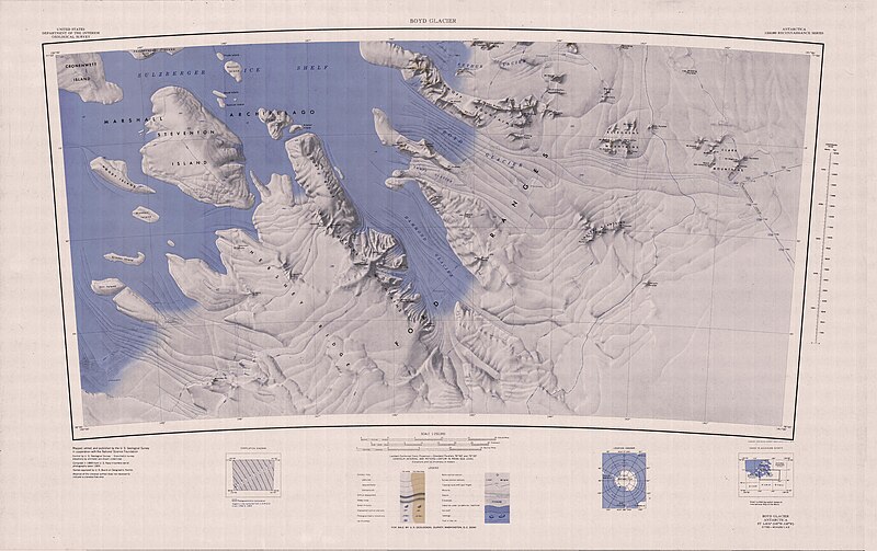
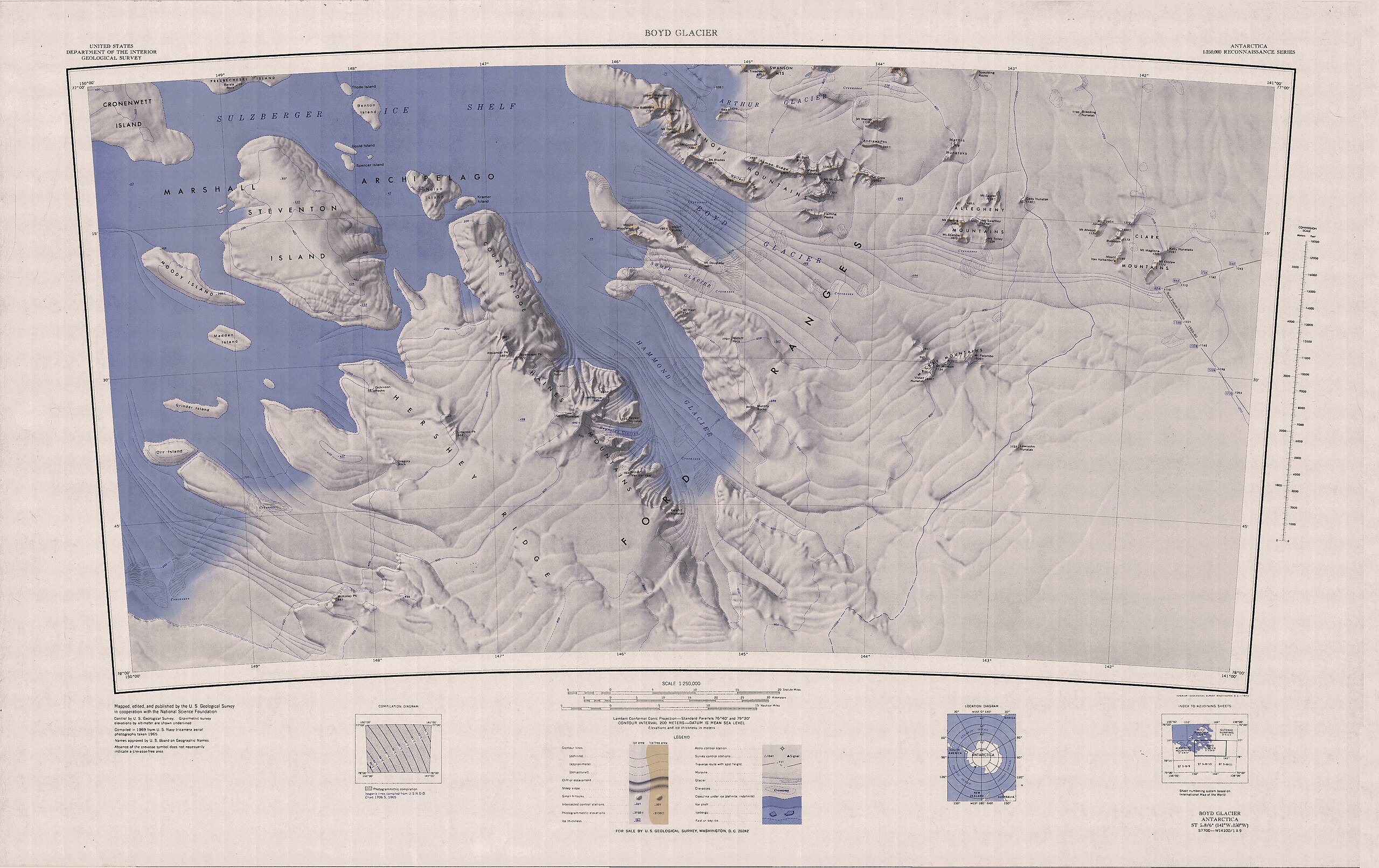
English: Map of Antarctica by the United States Antarctic Resource Center of the US Geological Society. |
| Born | USGS |
| Autor | USGS |
Dieses Bild ist gemeinfrei (public domain), weil es Materialien beeinhaltet, die ursprünglich vom United States Geological Survey, einer Behörde des Innenministeriums der Vereinigten Staaten, stammen. Weitere Informationen finden Sie in den Urheberrechtsbestimmungen des USGS
|
Datei-Historie
Klick op de Tiet, dat du de Datei ankieken kannst, so as se do utseeg.
| Datum/Tiet | Duumnagelbild | Grött | Bruker | Kommentoor | |
|---|---|---|---|---|---|
| aktuell | 18:23, 3. Apr. 2005 | | 5.164 × 3.250 (1,96 MB) | Achim Raschka | Map of Antarctica by the United States Antarctic Ressource Center of the US Geological Society. {{PD-US}} Copyrights and Trademarks USGS-authored or produced data and information are in the public domain. While the content of most USGS web pages is in th |
Dateibruuk
Disse Sieden bruukt dit Bild:
Allmeen Datei-Bruuk
Disse annern Wikis bruukt disse Datei:
- Bruuk op bg.wikipedia.org
- Bruuk op ceb.wikipedia.org
- Bruuk op de.wikipedia.org
- Ford Ranges
- Cronenwett-Insel
- Steventon-Insel
- Marshall-Archipel
- Court Ridge
- Haines Mountains
- Hammond-Gletscher
- Clark Mountains
- Allegheny Mountains (Antarktika)
- Grinder-Insel
- Alexander Peak
- Arthur-Gletscher (Antarktika)
- Swanson Mountains
- Boyd-Gletscher
- Asman Ridge
- Sarnoff Mountains
- Bailey Ridge
- Fleming Peaks
- Benton-Insel
- Nolan-Insel
- Buennagel Peak
- Mount Darling
- Dickinson Rocks
- Linwood Peak
- Hershey Ridge
- Mount Ronne
- McKinley Peak
- Gould Island (Antarktika)
- Spencer Island (Antarktika)
- Gregory Rock
- Kelly-Nunatakker
- Keyser-Nunatak
- Reynolds-Gletscher
- Kramer Island
- Leach-Nunatak
- Madden Island
- Moody Island
- Midkiff Rock
- Mount West
- Swope-Gletscher
- Orr Island
- Rucker Spur
- Mount Spencer
Kiek na mehr almeen Bruuk von disse Datei.