
Bild:Battle of the Marne - Map.jpg

Originaldatei (1.241 × 961 Pixel, Grött: 203 KB, MIME-Typ: image/jpeg)
| Disse Datei warrt direkt vun Wikimedia Commons inbunnen. Angaven to'n Autor un de Lizenz staht op de Sied to de Datei bi Commons. |

|
Dit Bild schull man noch wedder as SVG-Datei (Vektor-Grafik) tekent warrn. Dat hett en Reeg Vördelen; bi Commons:Media for cleanup steit dor mehr to. Wenn dat al en SVG-Datei dorto gifft, denn laad ehr hooch. Na dat Hoochladen kannst du disse Vörlaag gegen {{vector version available|Nee Dateinaam.svg}} utwesseln.
|


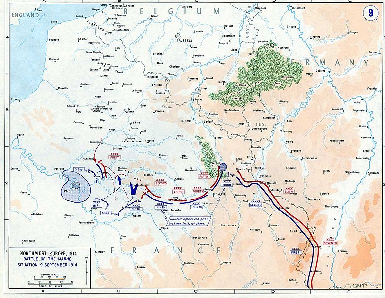
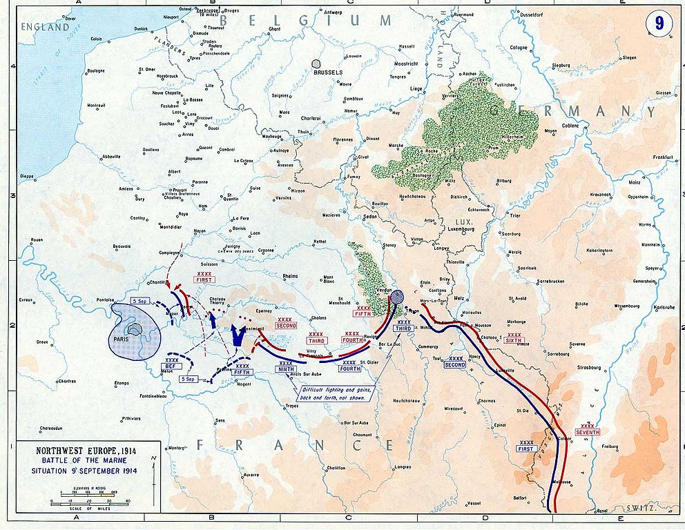
- Description: Battle of the Marne - Map - 5 September to 9 September 1914
- Source: www.dean.usma.edu
- Background information:
In 1938 the predecessors of what is today The Department of History at the United States Military Academy began developing a series of campaign atlases to aid in teaching cadets a course entitled, "History of the Military Art." Since then, the Department has produced over six atlases and more than one thousand maps, encompassing not only America’s wars but global conflicts as well.
In keeping abreast with today's technology, the Department of History is providing these maps on the internet as part of the department's outreach program. The maps were created by the United States Military Academy’s Department of History and are the digital versions from the atlases printed by the United States Defense Printing Agency. We gratefully acknowledge the accomplishments of the department's former cartographer, Mr. Edward J. Krasnoborski, along with the works of our present cartographer, Mr. Frank Martini.
Please be aware that these maps are large in file size and may require substantial download times.
Dieses Bild wurde von einem Mitglied der United States Army während der Ausführung seiner Dienstpflichten erstellt. Als eine Arbeit der Bundesregierung der Vereinigten Staaten ist dieses Bild in public domain.
|
 |
Datei-Historie
Klick op de Tiet, dat du de Datei ankieken kannst, so as se do utseeg.
| Datum/Tiet | Duumnagelbild | Grött | Bruker | Kommentoor | |
|---|---|---|---|---|---|
| aktuell | 12:22, 16. Jun. 2005 | | 1.241 × 961 (203 KB) | W.wolny |
Dateibruuk
Disse Sied bruukt dit Bild:
Allmeen Datei-Bruuk
Disse annern Wikis bruukt disse Datei:
- Bruuk op af.wikipedia.org
- Bruuk op ar.wikipedia.org
- Bruuk op azb.wikipedia.org
- Bruuk op ba.wikipedia.org
- Bruuk op be-tarask.wikipedia.org
- Bruuk op be.wikipedia.org
- Bruuk op bg.wikipedia.org
- Bruuk op ca.wikipedia.org
- Bruuk op cs.wikipedia.org
- Bruuk op da.wikipedia.org
- Bruuk op de.wikipedia.org
- Bruuk op el.wikipedia.org
- Bruuk op en.wikipedia.org
- Bruuk op eo.wikipedia.org
- Bruuk op et.wikipedia.org
- Bruuk op eu.wikipedia.org
- Bruuk op fi.wikipedia.org
- Bruuk op fr.wikipedia.org
- Bruuk op fy.wikipedia.org
- Bruuk op gl.wikipedia.org
- Bruuk op he.wikipedia.org
- Bruuk op hr.wikipedia.org
- Bruuk op hu.wikipedia.org
- Bruuk op id.wikipedia.org
- Bruuk op it.wikipedia.org
- Bruuk op ja.wikipedia.org
- Bruuk op ko.wikipedia.org
- Bruuk op lb.wikipedia.org
- Bruuk op lij.wikipedia.org
- Bruuk op lt.wikipedia.org
- Bruuk op nl.wikipedia.org
- Bruuk op nn.wikipedia.org
- Bruuk op no.wikipedia.org
Kiek na mehr almeen Bruuk von disse Datei.